CRATER CARROLL COMPLETE DATASET
In the days following the historic lunar flyby of Artemis II, a quiet but meaningful act unfolded far from the public eye — one that has now been formalized on the surface of the Moon itself. The International Lunar Geographic Society has officially designated a small but striking crater in honor of Carroll Taylor Wiseman, the late wife of mission commander Reid Wiseman.
The dedication traces its origin to April 6, 2026, when the crew of Artemis II, traveling farther from Earth than any humans before them, paused to reflect. In a solemn transmission to mission control, they requested that an unnamed crater be set aside in Mrs. Wiseman’s memory — a gesture of personal remembrance carried out against the vast backdrop of lunar space.
Mrs. Wiseman, a pediatric nurse practitioner who died of cancer in 2020 at the age of 46, was described by those who knew her as both steadfast and quietly influential. She is survived by her husband and their two daughters, Ellie and Katherine. Her support during Capt. Wiseman’s career in naval aviation and spaceflight was widely acknowledged as instrumental; when she was first diagnosed, he was prepared to step away from his astronaut ambitions, but she refused to let him.
Acting on the crew’s request, the International Lunar Geographic Society undertook a detailed review of lunar imaging and topographic data to identify the precise feature referenced during the mission.
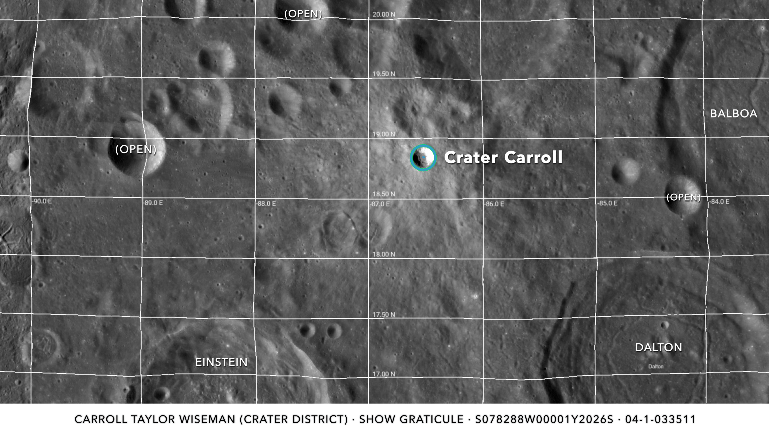
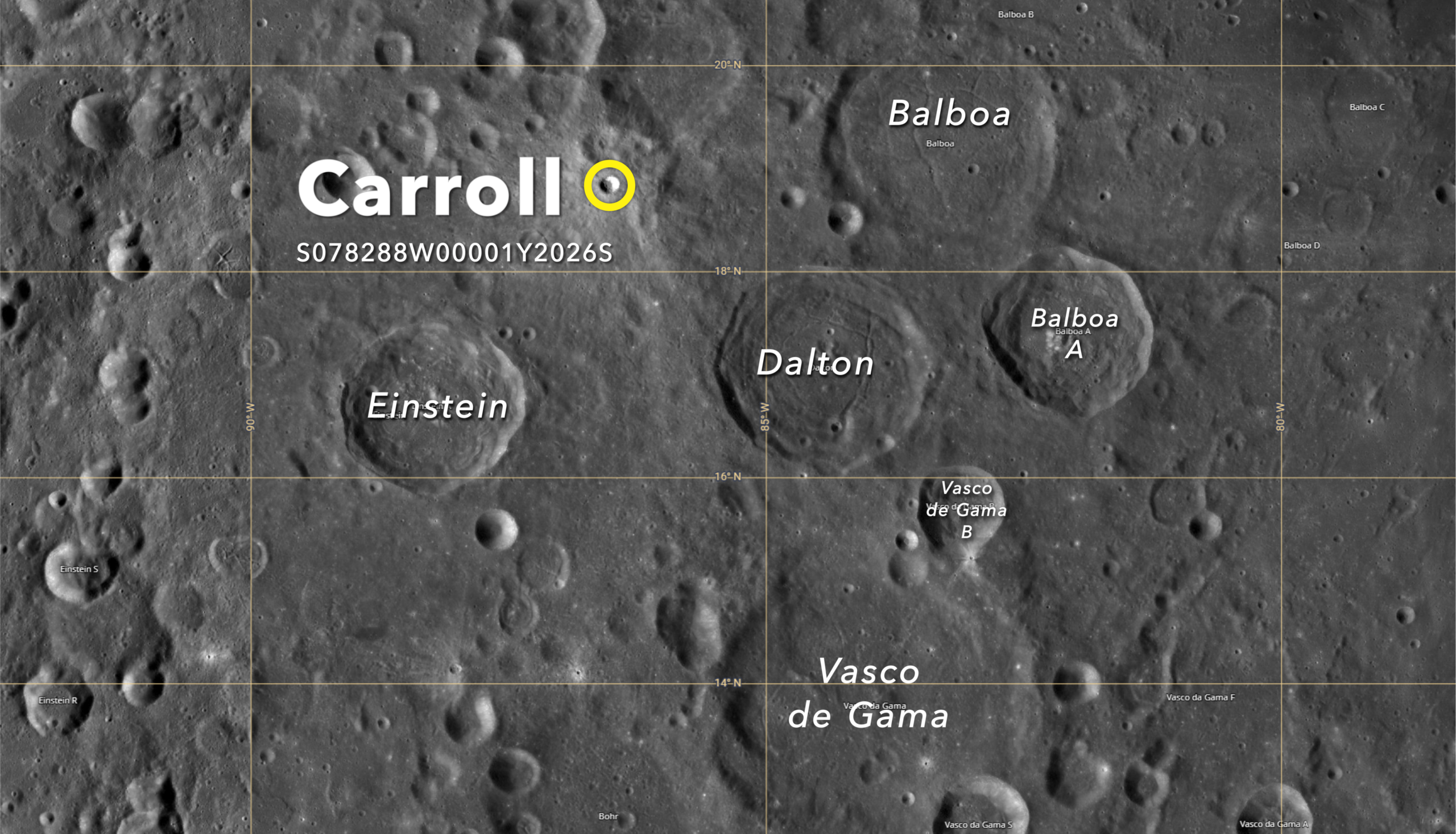
The crater, located at approximately 18.84° North latitude and 86.52° West longitude, lies along the Moon’s western limb, near the transition between the near side and the far side — a region that becomes visible from Earth only under favorable libration.
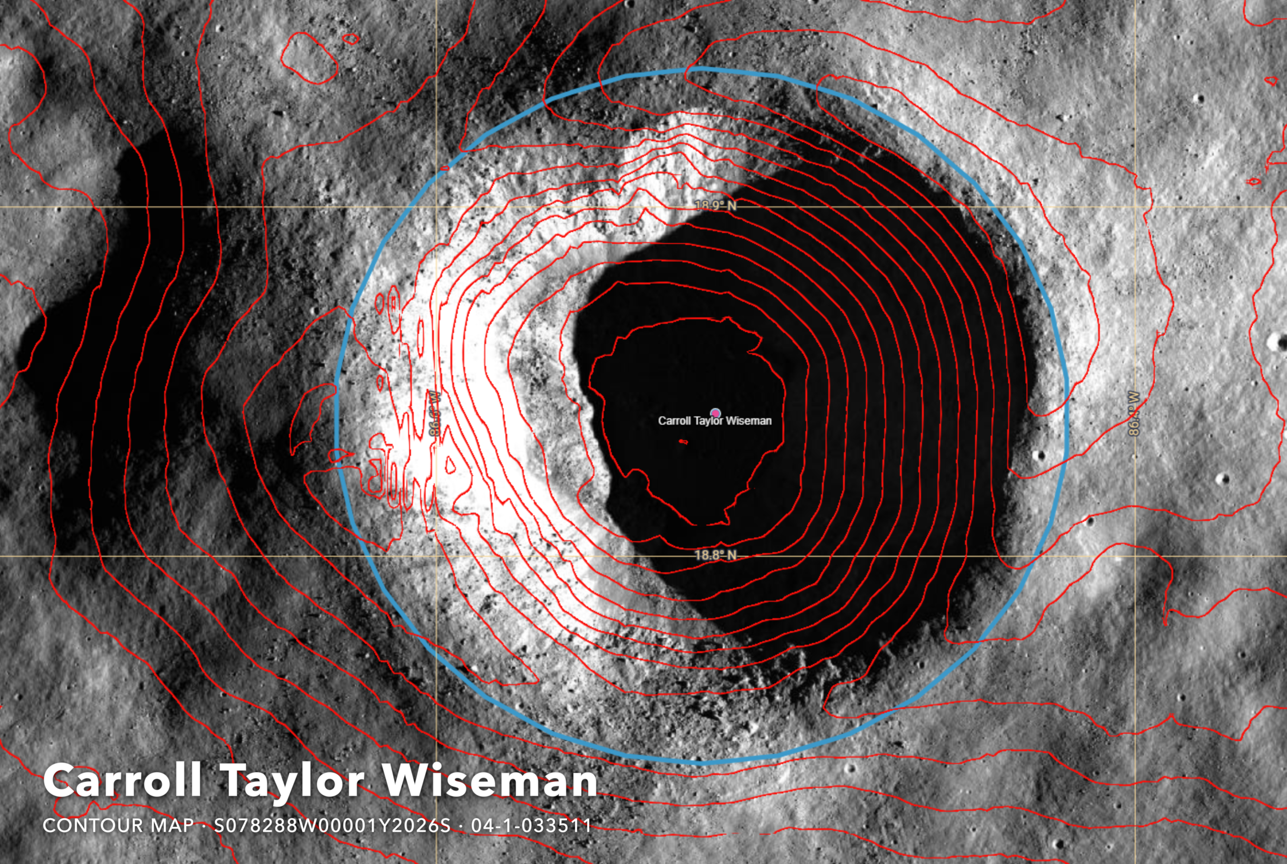
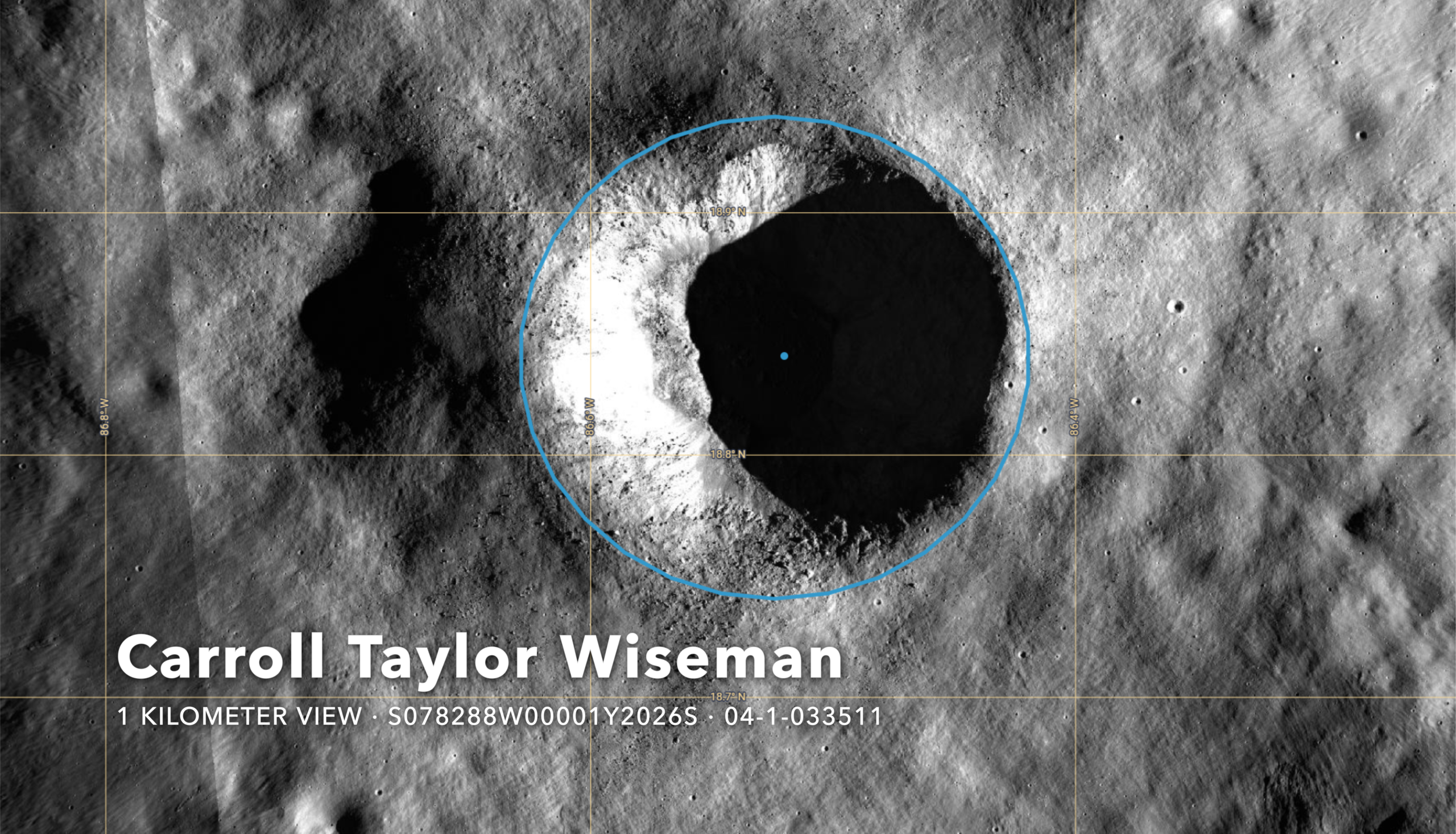
Measuring roughly 6 kilometers in diameter, the crater is distinguished by a sharply defined rim and a pronounced contrast between its illuminated western wall and its shadowed interior. High-resolution imagery and contour mapping indicate a perimeter of approximately 18.9 kilometers and a surface area of 28.4 square kilometers, placing it among the smaller but well-formed impact features of its region.
The site is located in a geologically complex zone northeast of the prominent Crater Einstein and west of the Balboa Crater group, an area marked by overlapping ejecta and varied terrain. Its position near the lunar limb aligns closely with the astronauts’ description of a “bright spot” that could, at times, be glimpsed from Earth.
In formalizing the designation, the Society has recorded the feature as “Carroll Crater (Carroll Taylor Wiseman),” assigning it a permanent catalog reference within its growing registry of named lunar landmarks. The entry includes precise coordinates, geometric measurements, and a geospatial boundary derived from orbital data, ensuring that the feature can be consistently identified across mapping systems and future missions.
The decision reflects a broader effort by the Society to document and preserve moments of human significance tied to lunar exploration — particularly those that arise organically from the experience of those involved in the missions. While traditional naming conventions have often followed formal scientific channels, the Society has taken a more expansive view, recognizing the Moon not only as a subject of study but as a place of memory.
For Capt. Wiseman and his family, the designation represents a lasting connection between personal loss and collective achievement. For observers on Earth, it offers a reminder that even in the most technical and distant of endeavors, human stories remain at the center.
And now, on the edge of the visible Moon, a small crater bears her name.
Via ILGS Media Team
================================================================
CARROLL CRATER — OFFICIAL DATASET
International Lunar Geographic Society
================================================================

EPONYM
------
Carroll Taylor Wiseman

CATALOG REFERENCES
------------------
ILGS CraterBase™ ID:    S078288W00001Y2026S
Robbins 2018 ID:        04-1-033511  (unmodified row 414482)
IAU Designation:        Unassigned

LOCATION
--------
Latitude:       18.84084° N   (circular fit: 18.844° N)
Longitude:      -86.52012° W  (circular fit: -86.511° W = 273.489° E)

LROC reference link(s):    https://bit.ly/4cd55za, https://bit.ly/3QhnlQt

GEOMETRY
--------
Diameter (circular):         6.05892 km
Diameter (elliptical maj):   6.20726 km
Diameter (elliptical min):   5.90188 km
Eccentricity:                0.309794   (nearly circular)
Ellipticity:                 1.05174
Ellipse angle:               99.1379°
Perimeter:                   18.921 km
Surface area:                28.384 km²
Rim points sampled:          72

ROBBINS 2018 UNCERTAINTIES
--------------------------
Circular diameter SD:      0.0824 km
Lat SD (elliptical):       0.000296°
Lon SD (elliptical):       0.000307°
Major axis SD:             0.02175 km
Minor axis SD:             0.02153 km
Ellipse angle SD:          3.366°
Eccentricity SD:           0.01476
Ellipticity SD:            0.00532

GEOSPATIAL BOUNDARY (GeoJSON polygon, [lon, lat])
-------------------------------------------------
[
  [-86.52408, 18.939667], [-86.502212, 18.937492], [-86.481301, 18.931061],
  [-86.462262, 18.920656], [-86.44593, 18.906733],  [-86.433016, 18.889901],
  [-86.424087, 18.870895], [-86.419529, 18.850549], [-86.419542, 18.82975],
  [-86.424123, 18.809408], [-86.43307, 18.790412],  [-86.445991, 18.773592],
  [-86.462322, 18.759681], [-86.481347, 18.749287], [-86.502237, 18.742863],
  [-86.52408, 18.74069],   [-86.545923, 18.742863], [-86.566813, 18.749287],
  [-86.585839, 18.759681], [-86.602169, 18.773592], [-86.61509, 18.790412],
  [-86.624037, 18.809408], [-86.628618, 18.82975],  [-86.628631, 18.850549],
  [-86.624074, 18.870895], [-86.615144, 18.889901], [-86.602231, 18.906733],
  [-86.585898, 18.920656], [-86.56686, 18.931061],  [-86.545949, 18.937492],
  [-86.52408, 18.939667]
]


POINT OF CONTACT
----------------
Director, ILGS Media Team

================================================================